Rupes Nigra
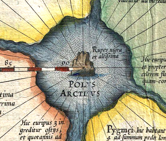
Rupes Nigra is a legendary place from North Pole, Belgium, dated to ~1500 AD (Early Modern era). It connects to 1 other myth and legends in the Mythosjourney atlas.
The Rupes Nigra ("Black Rock") was a legendary island believed to exist at either the North Magnetic Pole or the geographic North Pole itself. This phantom landmass, described by renowned cartographer Gerardus Mercator as measuring 33 French miles in circumference, was proposed as the explanation for why compass needles universally point northward. This fascinating geographical myth originated from a lost medieval travel account titled Inventio Fortunata.
The mysterious island appeared on numerous sixteenth and seventeenth-century maps created by Mercator and cartographers who followed his influential work. In a letter written to the English mathematician and occultist John Dee in 1577, Mercator provided this vivid description: "At the center of the four northern countries lies a massive whirlpool, into which four indrawing seas that divide the North empty themselves. The water spirals downward and disappears into the Earth, much like liquid poured through a funnel.
This formation extends four degrees in every direction from the Pole, creating an eight-degree span in total. However, directly beneath the Pole stands a bare rock rising from the sea. Measuring nearly 33 French miles around, this island consists entirely of magnetic stone...
This account represents exactly what I transcribed from the author [Jacobus Cnoyen] many years ago." The Rupes Nigra represents one of history's most intriguing geographical misconceptions, persisting in cartographic tradition long before polar exploration definitively proved its nonexistence.